Texas Heat Wave Forecast: Record-Breaking Temperatures Expected
A scorching heat wave is set to grip Texas this week, with temperatures soaring into the triple digits across much of the state. North Texas, including the Dallas-Fort Worth (DFW) Metroplex, will experience near-record heat as early as Tuesday, with Wednesday shaping up to be the hottest day. Here’s what you need to know about this unusual early-May heat wave, its causes, and how to stay safe.
Why Is This Happening?
The culprit behind this intense heat is a strong high-pressure system moving in from Mexico. This system will settle over the Gulf of Mexico and southern United States, driving hot, southwesterly winds across Texas. These winds, combined with clear skies and minimal moisture, will cause temperatures to skyrocket, especially in central and western parts of the state.
In North Texas, the region will sit on the edge of this high-pressure ridge, but it’s still close enough to push temperatures well above average. The added humidity in eastern Texas will slightly temper the heat, but most areas will still feel the brunt of this summer-like weather.
Temperature Forecast for North Texas
The heat wave kicks into high gear on Tuesday and peaks on Wednesday. Here’s a breakdown of the forecast for the DFW area:
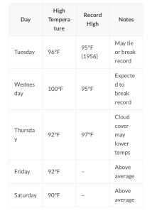
- The average high for this time of year in North Texas is
82°F, making these temperatures 10-18°F above normal. Wednesday’s forecast of 100°F in DFW could mark the earliest 100-degree day in recent years, though it won’t break the all-time record of March 9, 1911.Central and South Texas: Even Hotter
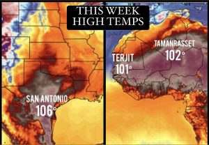
While North Texas will be hot, central and southern Texas will face even more extreme conditions. Cities like Austin, San Antonio, and Del Rio are expected to see widespread triple-digit temperatures, with some areas potentially reaching 107-108°F on Wednesday.
These temperatures could challenge all-time record highs for May.
- Austin: 103°F Tuesday, 105°F Wednesday, triple digits through Saturday.
- San Antonio: 104°F Tuesday, 107°F
Wednesday, triple digits into the weekend. - Del Rio & St. Angelo: Triple digits both days, with highs near 105°F.
The combination of extreme heat and humidity in these areas raises the risk of heat-related illnesses, especially for those working outdoors or without access to air conditioning.
How Unusual Is This Heat?
While May can bring warm days, a 100-degree day this early is rare. On average, DFW sees its first 100-degree day around July 1st, based on data from 1991-2020. Recent years have seen first triple-digit days as early as June 11 (2022) or as late as July (2019-2021).
A 100-degree day in early May would be among the earliest in recent decades, though not as extreme as the record set on March 9, 1911.
Historically, DFW averages about 20 days above 100°F per year. In 2023, the region saw 55 such days, while 2011 holds the record with 71 days. The notorious 1980 summer saw every day in July above 100°F, with a peak of 113°F on June 26-27. While this week’s heat wave won’t reach those extremes, it’s a stark reminder of Texas’ capacity for intense heat.
What to Expect Later in the Week
By Thursday, the high-pressure ridge will shift slightly south, allowing more cloud cover and a southwest flow to develop. This could bring scattered thunderstorms, particularly along the dry line in western Texas, starting Thursday and continuing through the weekend. These storms may reduce temperatures to the low 90s in North Texas, still above average but not record-breaking.
Long-range forecasts suggest an above-normal chance of precipitation from days 6-10, which could further cool things down with clouds and rain. However, temperatures are expected to remain above average through at least May 22.
Staying Safe in the Heat
This heat wave poses risks, especially for vulnerable groups like the elderly, children, and pets. Here are key safety tips:
- Stay Hydrated: Drink plenty of water, even if you don’t feel thirsty.
- Avoid Outdoor Activity: Limit strenuous activity during the hottest parts of the day (10 a.m. to 4 p.m.).
- Check on Others: Ensure elderly neighbors and relatives have access to cooling and hydration.
- Protect Pets: Provide ample water and shade, and avoid walking pets on hot pavement.
- Recognize Heat Illness: Watch for symptoms like dizziness, nausea, or confusion, and seek medical help if needed.
Viewer Question: “How can it go from the 50s this morning to 100°F by Wednesday?”
It’s not uncommon in Texas for temperatures to swing dramatically. The incoming high-pressure ridge and westerly winds can drive rapid warming, especially with low humidity allowing the sun to heat the air efficiently.
Looking Ahead
This heat wave is a taste of summer in early May, but relief is on the horizon. By the end of the week, increased cloud cover and potential thunderstorms should bring temperatures down to more manageable levels. Until then, stay cool, stay safe, and prepare for a few days of intense heat across Texas.